Search This Blog

Thursday, 3 August 2017

The Falls!!!!


On the eastern side of the island, along the Windward Road on the way to Roxborough, Argyle Falls provides an excellent do-it-yourself nature walk for those who may need to work off too many helpings of breadfruit pie. The hike to the falls is pretty easy, about 15 – 20 minutes of relatively flat ground.

The trail is very clearly marked, so there’s no need for a guide. Entry costs about TT$50 and guides are available for an additional fee. You’ll walk along the riverbed through serene forest to the falls themselves. The more adventurous will attempt to climb them, but unless you’re a seasoned hiker and rock climber, it may be better to stay in the refreshing pools at the foot of the falls and take in the splendor of nature from below.

As a vacation destination, Tobago offers visitors historical nuggets, ecotourism gems and natural serenity. Argyle Waterfall is the highest waterfall in Tobago, and the facilities and guides available on site make it very attractive to visitors. Getting there is very easy, as just before the town of Roxborough in the northeast of the island, there is a large welcome sign marking the access road (Cameron Canal road). The Argyle Waterfalls are Tobago's highest waterfalls, tumbling 54m (175ft) in a series of stepped cascades.

Come and unwind from that stressful week of stressful life, plan that vacation you’ve been putting off and come to our beautiful destinations here at Tobago!!!

Wednesday, 2 August 2017

Stone Haven !!!


Stonehaven Bay is a picturesque beach destination that comprised of soft, light brown, medium grain sand that is ideal for destination weddings, leisurely romantic walks, sunbathing, snorkeling, kayaking and surfing.

Located off the Grafton Road between Mt. Irvine and Black Rock in south west Tobago, Stonehaven Bay is great for snorkeling towards its northern end closer to the Grafton Beach Resort. If you are interested in turtle watching, then you are in luck as the Bay is one of the few destinations in Tobago where the leatherback turtle nests between the months of March and June. The attractive golden sands combined with the cool breezes coming off of the bay and the natural beauty of the location makes for the perfect setting for a intimate destination wedding.

Stonehaven Bay is a picturesque beach destination that comprised of soft, light brown, medium grain sand that is ideal for destination weddings, leisurely romantic walks, sunbathing, snorkeling, kayaking and surfing.

Bodysurfing and swimming in the waters of Stone Haven Bay is a refreshing and fun way to release any stress and tension that you may be carrying around from back home. Renting a canoe to explore the deep waters further out is also a possibility, making this beach one of the most versatile on the island.

Across from the large Grafton Hotel on the west coast of Tobago is the long stretch of sand that is Stonehaven Bay beach. Golden sands lead to gorgeous blue waters that are great for swimming and riding the surf. Turtles come to lay their eggs on the beach in the spring and sometimes you can spot an endangered leatherback turtle laying eggs in the sand. When you aren't on the lookout for turtle eggs, you'll notice that umbrellas and recliners dot the landscape -- they are offered to beach goers free of charge by a nearby hotel.


There is also a snack bar here. Depending on the season and time of day, you may also be able to buy food from one of the local vendors who typically operate along this coastline.

Couple's Retreat


Set in Man O War Bay, Lover's Beach is situated along the western curve of the crescent. This beach serves as a great place to enjoy the Caribbean Sea without heavy crowds kicking sand in your face or blocking your view of the horizon.

Positioned on the northeastern side of the island of Tobago, 1.5 miles west-southwest of Charlotteville. It is solely entered by boat. . 


You have to hire a local to bring you to this isolated retreat of pink sand. Ask one of the fishermen in Charlotteville to arrange a ride for you, but be sure to haggle.

Back Bay !!!!


Nestled between Mount Irvine and Grafton lies a secluded patch of paradise. The adventure begins with the access the beach. The unmarked entrance is directly opposite Gleneagles Drive and visitors must park along Shirvan Road. After passing an abandoned estate property, prospective beach-goers begin a trek over a cliff side trail to journey to the beach set below the cliff of rugged rocks.

Back Bay is a quiet secluded beach that attracts large numbers of body surfers and surfers. Access to the beach involves a bit of a scramble but is worth it in the end. It is undoubtedly one of the most beautiful beaches on Tobago, but due to the isolated nature of the beach, its best to go with a group.

At 500 meters in length, the Bay is short but one of the most beautiful beaches in Tobago. Large rocks spot the coastline while pretty small fish swim in the crystal clear waters close to the shore. Boulders on the western end make for an exciting snorkeling and scuba diving setting. A natural pool is filled with the tide as water flows in and out; a hidden spot that nature seems to have created just for two.

There are no washroom facilities, lifeguards or restaurant and bars on this beach which is something to consider if you intend to spend all day lounging on the isolated beach. Though it is generally underpopulated, Back Bay is a favorite among body surfers and surfers as there are good body surfing waves.


Back Bay is an 8-minute walk from the Mount Irvine Bay hotel. Snorkeling, body surfing and tanning is generally excellent at this bay. It also very secluded so best go in a group.

Tuesday, 1 August 2017

The Perfect Spot!!!


Pigeon Point Heritage Park is a 125 acre nature reserve on the southwestern coast of Tobago. Home to the award-winning Pigeon Point Beach, this multifaceted facility has long been a defining feature of tourism in Tobago. Located just a few minutes from the ANR Robinson International Airport, this oasis is a wonderfully accessible escape from the life's busy pace.

The sand at Pigeon Point is one of Tobago’s finest with a seashell tint and the water”s colour, a mixture of bright turquoise and teal. This beach is well known for the constant hub of activities partly due to its proximity to the ANR Robinson International Airport and the major hotels which surround it.

Along the roadside, before entering the Pigeon Point park, one will find dive shops, tour operators, road side vendors selling an assortment of beach paraphernalia, locally made crafts and even cold coconut water.

The beach makes up part of the Pigeon Point Heritage Park. Visitors, upon paying the entrance fee of $18.00, may enjoy the park in its entirety: secure parking, washroom facility and changing rooms, small shops, seating areas that include thatched-roof huts ideal for picnicking, the occasional live entertainment, and the leisurely stroll in the park.


This is one of the more popular spots for it offers two sports bars that often highlight game days and stream live matches and events, also it’s the perfect backdrop for your beach wedding. 

Little Tobago !!


This little island, just a mile across, is a bird sanctuary popular with walkers and birders. It hosts one of the largest seabird colonies in the Caribbean and is reached from Speyside by pirogue or glass bottomed boat - a 15 minute trip over coral reefs across Tyrell’s Bay, passing Little Goat Island.
Long ago, Little Tobago was a preferred hiding spot for pirates. When agriculture and trade started to flourish in this part of the West Indies, the pirates were driven from their rocky shelters of Tobago’s coastlines. Little Tobago, in fact, became a successful spot for planting cotton.

Archaeological evidence suggests that the island may have been occupied at some time by “First People” groups. In a population survey done in 1790, five “Amerindian” individuals were reported on the island of Little Tobago. However, further archaeological study is needed to fully understand the nature of this early human activity. The island became a cotton plantation of some significance in the latter half of the 18th century. The planter, a Scotsman, erected a wooden house and quarters for the enslaved Africans he used as a source of labor. The island was purchased in 1983 by Sir William Ingram. As an avid environmentalist, Sir William introduced the Greater Birds-of-Paradise (Paradisaea apoda) to the island in an attempt to save the species from over hunting for the plume trade in its native New Guinea. After his death in 1924 the island was sold to the government of Trinidad and Tobago as a wildlife sanctuary.

Have you ever had the pleasure of meeting a lazy barracuda? Have you seen the long tail streamer that came very close to beating the scarlet ibis to the title of our national bird? How about viewing the remains of the largest brain coral in the western hemisphere? Three hours spent on and around the island formerly known as Bird-of-Paradise Island was enough for an adventure that will live long in my memory. The following are five things about this experience that all Trinbagonians should be aware of.

There are no streams or watercourses, the island has only one spring that is dry for several months of the year. As a result, vegetation on the island can be mostly described as deciduous seasonal forest. Two of the most notable species of flora on the island are the Large Ground Anthuriums and the Texas Man drone (Naked Indian Tree). They were found on the ground and on the branches of trees. The plant is noted for its interesting method of gathering nutrients. Its leaves are positioned in such a way that it traps falling foliage thereby ensuring its survival on the predominantly limestone island. The Naked Indian Tree is so dubbed because of its interesting exfoliating bark. When the older layers slough off, the newer bark is smooth and can range from white to orange through shades of apricot to dark red. 

   
When travelling to Little Tobago via Speyside you will first happen upon Goat Island. This ten acre landmass lies just west of the Angel Reef, a popular scuba diving site that boasts one of the largest brain coral specimens left in the world. The island’s most identifiable characteristic is the large white house located at it’s the center.

On our way to Little Tobago we sailed over Angel Reef and Japanese Gardens. Through our glass bottom boat we spied a wondrous variety of marine life. As their names suggest, the reefs are a veritable garden of angelic splendor. They consist of both hard and soft coral which play host to beautifully varied array of fish and other aquatic animals. We saw Groupers, Jacks, Sergeant Major fish, Parrot fish, Trumpets, and luckily an adolescent hawksbill turtle. By far the most interesting spectacle in this reef complex was the largest brain coral found in the western hemisphere. This single colony is comprised of millions of individual coral animals and is a sight to behold.


A short hike to the highest point on the island resulted in a spectacular ocean view that spanned the entire distance of our journey from Speyside. The steep cliffs in view hosted a variety of seagoing avifauna. We were lucky enough to glimpse species like the Audubon’s shearwater and Brown Booby. In my opinion the most magnificent was the Red-Billed Tropicbird. Its black and white feathers and red bill made it a candidate for our national bird but as we know, the scarlet ibis was victorious in that regard.

These were just a few of the things we did and saw on and around Little Tobago. The flora, fauna geography and history of the island are all exceptional aspects of our heritage that should be protected. This experience was something that I won’t soon forget!

Sunday, 30 July 2017

Vacation equals Arrrrrr N Arrrrrr


Pirate’s Bay is named for the buccaneers that used it as a shelter centuries ago. Some say there is still buried treasure to be found inland at the bay. No matter the case it is certainly one of the best beaches and most rewarding I have come across.

Pirate’s Bay is a beautiful hidden spot located near Charlotteville on the north-eastern part of Tobago. Getting to the beach itself is not very easy, as you need to walk for a while. Down the stairs with a lot more than 150 steps you finally get to the incredible beach. The easy way to get there is asking a fisherman in Man of War Bay to take you by boat.


Pirate’s Bay Beach is only accessible on foot or by boat, which means it does not receive a lot of daily visitors. Only the most adventurous make it all the way to Charlotteville, Tobago and onwards to Pirate’s Bay. The walk from the center of town will lead you along the water’s edge and onto a road used by some off-road motorists. Only the brave of heart will dare to drive this one way path, with treacherous cliffs and bends. Follow the trail past the grazing goats and pause at every turn to look back at the breathtaking views of Charlotteville.

When you reach the end of the trail along the coast you will come to a fork. To the right you will find eco-guesthouses and to the left you will find the downward path to Pirate’s Bay. Test your body’s limit and hike to the bay, swim, play beach football, be careful not to ware yourself out as the trek to the beach may have been strenuous but that is nothing until the return on the way back up those stairs.


The hike from the center of town is only 20 minutes but on a hot day climbing up and down through the trees you will surely be relieved when your feet touch the cool sand. 

Saturday, 29 July 2017

Old Cities !!!


Tobago is one of those Caribbean islands with a long, sometimes bloody history changing hands between European colonial powers — thirty-three times in three centuries is the dizzying number, with the Dutch, the French, and the English the chief rivals, or culprits. Colonists of these nations made several attempts to establish settlements on Man O’War Bay, and by the late eighteenth century there was a sugar plantation established near the location of present-day Charlotteville, thriving under the backbreaking labour of enslaved Africans. 


As a result, the village of Charlotteville was directly influenced by this history of imperialism and colonialism. Within the village existed several agricultural estates which were fairly profitable during the era of enslavement. The villagers during this time were involved in sugar cultivation, and later on, during the period of 1916-1918, began experimenting with banana which was a rising success as well as cocoa for commercial purposes, which proved a successful venture for the agriculturalists. By 1946, according to the census reports of that year, the area had a total of 277 households and as many as 1,360 people including some Grenadians who came to Tobago, possibly due to the shortage of agricultural labour during the war (WWII).


Charlotteville today is a fishing village of around 2000 people. Its long village beach of soft creamy sand is backed by a few cottages and a few small shops and bars owned by villagers. Fifteen minutes walk along a track is Pirates’ Bay, one of the most beautiful beaches in Tobago, where there are no permanent buildings and no roads. Some of the village houses have two or three guest rooms and there are several small guesthouses. There are a few, simple restaurants.
Also popular in Charlotteville are guided tours and hikes through the rainforest, the oldest protected rainforest in the western hemisphere and which is still visibly scarred by Hurricane Flora. Little Tobago is only a few miles away from the coast and is a popular site for bird watching and other explorations. 


Charlotteville also has small tamboo bamboo bands (the rhythms are produced by pounding bamboo on the earth) which had originated during the era of enslavement when Africans were debarred from playing their traditional musical instruments.


Sunday, 23 July 2017

The Great Battle at Sea!!!


Tiny, peaceful Tobago was once the scene of one of the bloodiest sea battles ever fought – one that saw 20 ships destroyed and sunk to the bottom of the sea. The year was 1677, and over 2,000 people, including 250 French and Dutch women and children and 300 African slaves, met horrific deaths in the waters.

When the British admiral Sir John Harman encountered the combined fleets of France and Holland which had rendezvoused off a bay then called Anse Erasme or Rash House Bay, now known as Bloody Bay on the north-west or leeward side of the island. It is said that the British defeated them with such great slaughter that the sea ran red in the golden sunset, the cannon booming into the night. Today, giant immortelle trees bloom a brilliant scarlet red on the mountains above Bloody Bay.
The island was called “Bellaforma” by Christopher Columbus when he came upon it in 1498, because it was so beautiful. It came to be highly prized and changed hands more than 30 times as several European nations fought over the island. But little is said or known about the human toll of these military dramas.

The early Dutch maps give it the name 'Rasphuys Bay'. Rasphuis, according to English historian Simon Schama, was a 17th century workhouse in Amsterdam where brazilwood was powdered to produce dye. The timber was rasped by convicts, and hence the name 'rasp house'. Indeed, until 50 years ago Parlatuvier, the village in the next bay, still had a sawmill and one of the most important dyewoods from the district, called redwood, also known as 'bloodwood', for it red stained look. Was Bloody Bay a similar user of ' bloodwood'.

We will make you Fishers of Men - A catch of biblical proportions. Early April 2001 the Bloody Bay seine fishermen hauled in a record catch, probably Tobago's largest in living history. They ran out of vans to take the fish to Scarborough market. The villagers of Bloody Bay had their fill, one lady was carrying so much that she fell over. A number of local buses detoured to the beach where the drivers and passengers all helped themselves to the catch. Hugh quantities were salted for later use. Still many were buried to prevent pollution. Thanks was given to God for his blessings.
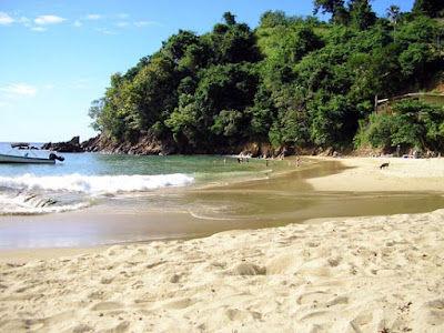

This is one of these places in Tobago where you don’t need to be a photographer. Any picture you take here is going to look good. This beach has everything including a nice surrounding with a river entering the sea, rocks, and an unspoilt background and so on. It’s a bit of a drive to reach located between Parlatuvier and Charlottesville, but even the trip itself is – as with most – already worth going. You can take the route over the north and the south side of Tobago to reach Bloody Bay. If you take the south side you can either make a circle through Charlottesville or make a short cut through the rainforest, which leads you straight to Bloody Bay.

Another fun fact !!!

Although little is said or known about the human toll of these military dramas. This will soon change, when the incredible story of two gut-wrenching battles comes to light in a movie docudrama called Tobago 1677. The team behind the local production company Oceans Discovery Tobago Ltd, German filmmaker Rick Haupt and photographer Sylvia Krueger, are architects of an ambitious, technically challenging movie that will raise the seventeenth-century ghosts from their watery grave and potentially put Tobago on the map for its unique archaeological heritage.

Follow the link for more info on the documentary: https://www.youtube.com/watch?v=8I3nMn3ACjI

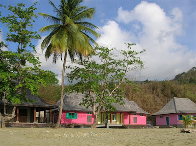
Once your done dipping in the calm waters there is the lovely and newly built beach facilities, all painted in the beautiful vibrant colors, if you’d rather a fun filled family day, where you fire up the grill and load the coolers with your favorite drinks, bloody bay is the beach for you. 

Englishman's Bay-The Crescent Beach


On the leeward coast of Tobago, if you look carefully, you will find Englishman’s Bay – a picturesque secluded beach which despite its lack of popularity among beach-goers is arguably Tobago’s most beautiful beach destination.  

The beach itself is a classic crescent shape, capped by two heavily forested headlands descending from Tobago's Main Ridge. Counted among the top 10 beaches in the Caribbean by many travel magazines and websites, this beach is indeed a diamond in the rough. Located between Castara and Parlatuvier about 1. 5 km past Castara, the beach is not visible from the Northside Road. Locating it requires a keen eye for a blue and white sign indicating a left turn. Follow the unpaved road to the end and there you will find the classic crescent shaped beach nestled between the thick tropical rain forest and the clear blue Caribbean Sea.

The sand starts immediately after the forest ends and is of a shallow to medium gradient and somewhat coarse grain. With tracks lined with interwoven trees, makes for a beautiful backdrop. 

The beach itself does not change size drastically at high or low tides, due to the gradient. The waters are calm year-round, with swells growing slightly in size toward the winter months, and boast magnificent snorkeling and swimming.


The destination is ideal for swimming, snorkeling and camping. Chairs, umbrellas and snorkeling equipment can be rented. It is a nesting ground for the leather back turtle and is a popular mooring spot for yachts.

There is food on sale as well as local craft. Also situated is a classic tree-house restaurant, where you can grab a bite of some of Tobago's best local dishes. 


The Falls!!!!

On the eastern side of the island, along the Windward Road on the way to Roxborough, Argyle Falls provides an excellent do-it-yourself ...