Search This Blog

Sunday, 30 July 2017

Vacation equals Arrrrrr N Arrrrrr


Pirate’s Bay is named for the buccaneers that used it as a shelter centuries ago. Some say there is still buried treasure to be found inland at the bay. No matter the case it is certainly one of the best beaches and most rewarding I have come across.

Pirate’s Bay is a beautiful hidden spot located near Charlotteville on the north-eastern part of Tobago. Getting to the beach itself is not very easy, as you need to walk for a while. Down the stairs with a lot more than 150 steps you finally get to the incredible beach. The easy way to get there is asking a fisherman in Man of War Bay to take you by boat.


Pirate’s Bay Beach is only accessible on foot or by boat, which means it does not receive a lot of daily visitors. Only the most adventurous make it all the way to Charlotteville, Tobago and onwards to Pirate’s Bay. The walk from the center of town will lead you along the water’s edge and onto a road used by some off-road motorists. Only the brave of heart will dare to drive this one way path, with treacherous cliffs and bends. Follow the trail past the grazing goats and pause at every turn to look back at the breathtaking views of Charlotteville.

When you reach the end of the trail along the coast you will come to a fork. To the right you will find eco-guesthouses and to the left you will find the downward path to Pirate’s Bay. Test your body’s limit and hike to the bay, swim, play beach football, be careful not to ware yourself out as the trek to the beach may have been strenuous but that is nothing until the return on the way back up those stairs.


The hike from the center of town is only 20 minutes but on a hot day climbing up and down through the trees you will surely be relieved when your feet touch the cool sand. 

Saturday, 29 July 2017

Old Cities !!!


Tobago is one of those Caribbean islands with a long, sometimes bloody history changing hands between European colonial powers — thirty-three times in three centuries is the dizzying number, with the Dutch, the French, and the English the chief rivals, or culprits. Colonists of these nations made several attempts to establish settlements on Man O’War Bay, and by the late eighteenth century there was a sugar plantation established near the location of present-day Charlotteville, thriving under the backbreaking labour of enslaved Africans. 


As a result, the village of Charlotteville was directly influenced by this history of imperialism and colonialism. Within the village existed several agricultural estates which were fairly profitable during the era of enslavement. The villagers during this time were involved in sugar cultivation, and later on, during the period of 1916-1918, began experimenting with banana which was a rising success as well as cocoa for commercial purposes, which proved a successful venture for the agriculturalists. By 1946, according to the census reports of that year, the area had a total of 277 households and as many as 1,360 people including some Grenadians who came to Tobago, possibly due to the shortage of agricultural labour during the war (WWII).


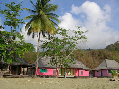
Charlotteville today is a fishing village of around 2000 people. Its long village beach of soft creamy sand is backed by a few cottages and a few small shops and bars owned by villagers. Fifteen minutes walk along a track is Pirates’ Bay, one of the most beautiful beaches in Tobago, where there are no permanent buildings and no roads. Some of the village houses have two or three guest rooms and there are several small guesthouses. There are a few, simple restaurants.
Also popular in Charlotteville are guided tours and hikes through the rainforest, the oldest protected rainforest in the western hemisphere and which is still visibly scarred by Hurricane Flora. Little Tobago is only a few miles away from the coast and is a popular site for bird watching and other explorations. 


Charlotteville also has small tamboo bamboo bands (the rhythms are produced by pounding bamboo on the earth) which had originated during the era of enslavement when Africans were debarred from playing their traditional musical instruments.


Sunday, 23 July 2017

The Great Battle at Sea!!!


Tiny, peaceful Tobago was once the scene of one of the bloodiest sea battles ever fought – one that saw 20 ships destroyed and sunk to the bottom of the sea. The year was 1677, and over 2,000 people, including 250 French and Dutch women and children and 300 African slaves, met horrific deaths in the waters.

When the British admiral Sir John Harman encountered the combined fleets of France and Holland which had rendezvoused off a bay then called Anse Erasme or Rash House Bay, now known as Bloody Bay on the north-west or leeward side of the island. It is said that the British defeated them with such great slaughter that the sea ran red in the golden sunset, the cannon booming into the night. Today, giant immortelle trees bloom a brilliant scarlet red on the mountains above Bloody Bay.
The island was called “Bellaforma” by Christopher Columbus when he came upon it in 1498, because it was so beautiful. It came to be highly prized and changed hands more than 30 times as several European nations fought over the island. But little is said or known about the human toll of these military dramas.

The early Dutch maps give it the name 'Rasphuys Bay'. Rasphuis, according to English historian Simon Schama, was a 17th century workhouse in Amsterdam where brazilwood was powdered to produce dye. The timber was rasped by convicts, and hence the name 'rasp house'. Indeed, until 50 years ago Parlatuvier, the village in the next bay, still had a sawmill and one of the most important dyewoods from the district, called redwood, also known as 'bloodwood', for it red stained look. Was Bloody Bay a similar user of ' bloodwood'.

We will make you Fishers of Men - A catch of biblical proportions. Early April 2001 the Bloody Bay seine fishermen hauled in a record catch, probably Tobago's largest in living history. They ran out of vans to take the fish to Scarborough market. The villagers of Bloody Bay had their fill, one lady was carrying so much that she fell over. A number of local buses detoured to the beach where the drivers and passengers all helped themselves to the catch. Hugh quantities were salted for later use. Still many were buried to prevent pollution. Thanks was given to God for his blessings.
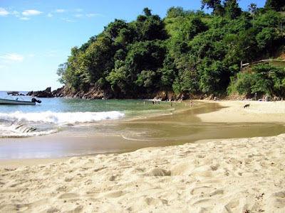

This is one of these places in Tobago where you don’t need to be a photographer. Any picture you take here is going to look good. This beach has everything including a nice surrounding with a river entering the sea, rocks, and an unspoilt background and so on. It’s a bit of a drive to reach located between Parlatuvier and Charlottesville, but even the trip itself is – as with most – already worth going. You can take the route over the north and the south side of Tobago to reach Bloody Bay. If you take the south side you can either make a circle through Charlottesville or make a short cut through the rainforest, which leads you straight to Bloody Bay.

Another fun fact !!!

Although little is said or known about the human toll of these military dramas. This will soon change, when the incredible story of two gut-wrenching battles comes to light in a movie docudrama called Tobago 1677. The team behind the local production company Oceans Discovery Tobago Ltd, German filmmaker Rick Haupt and photographer Sylvia Krueger, are architects of an ambitious, technically challenging movie that will raise the seventeenth-century ghosts from their watery grave and potentially put Tobago on the map for its unique archaeological heritage.

Follow the link for more info on the documentary: https://www.youtube.com/watch?v=8I3nMn3ACjI

Once your done dipping in the calm waters there is the lovely and newly built beach facilities, all painted in the beautiful vibrant colors, if you’d rather a fun filled family day, where you fire up the grill and load the coolers with your favorite drinks, bloody bay is the beach for you. 

Englishman's Bay-The Crescent Beach


On the leeward coast of Tobago, if you look carefully, you will find Englishman’s Bay – a picturesque secluded beach which despite its lack of popularity among beach-goers is arguably Tobago’s most beautiful beach destination.  

The beach itself is a classic crescent shape, capped by two heavily forested headlands descending from Tobago's Main Ridge. Counted among the top 10 beaches in the Caribbean by many travel magazines and websites, this beach is indeed a diamond in the rough. Located between Castara and Parlatuvier about 1. 5 km past Castara, the beach is not visible from the Northside Road. Locating it requires a keen eye for a blue and white sign indicating a left turn. Follow the unpaved road to the end and there you will find the classic crescent shaped beach nestled between the thick tropical rain forest and the clear blue Caribbean Sea.

The sand starts immediately after the forest ends and is of a shallow to medium gradient and somewhat coarse grain. With tracks lined with interwoven trees, makes for a beautiful backdrop. 

The beach itself does not change size drastically at high or low tides, due to the gradient. The waters are calm year-round, with swells growing slightly in size toward the winter months, and boast magnificent snorkeling and swimming.


The destination is ideal for swimming, snorkeling and camping. Chairs, umbrellas and snorkeling equipment can be rented. It is a nesting ground for the leather back turtle and is a popular mooring spot for yachts.

There is food on sale as well as local craft. Also situated is a classic tree-house restaurant, where you can grab a bite of some of Tobago's best local dishes. 


Thursday, 13 July 2017

The Beauty of Nature !!!

Tobago was once joined to the South American mainland, and has inherited a continental legacy of plants, birds, insects, mammals and topography. Tobago is the smaller, relatively northeasterly island of the Republic of Trinidad and Tobago, with a surface area of about 316 km2. The Main Ridge is literally the backbone of the island, gutting lengthways across two thirds of Tobago's surface. It encompasses 3958 hectares (9780 acres) of tropical rainforest.


This area receives the greatest amount of rainfall, the greatest exposure to wind and the lowest temperatures, making it an evergreen forest. The lowland rainforest is characterized by copious growth and is said to be the most prolific of all forest types, occurring here to a maximum of 366 metres. Its small size, 21 miles long and seven miles wide, offers easy access to tropical rain forests, idyllic white sand beaches, waterfalls and lagoons. For centuries, Tobago’s unique worth has been appreciated and protected, on both land and sea. Tobago’s central mountain range, the Main Ridge (rising to 876m/1,890ft), encompasses the oldest protected rainforest in the western hemisphere, which became a reserve in 1764.

The Tobago Main Ridge Forest Reserve is on record as the oldest legally protected forest reserve geared specifically towards a conservation purpose. It was established on April 13th, 1776 by an ordinance which states in part, that the reserve is "for the purpose of attracting frequent showers of rain upon which the fertility of lands in these climates doth entirely depend." The passage of the ordinance is attributed to Soame Jenyns, a member of the British parliament whose main responsibilities were trade and plantation. He was influenced by the ideas of the English scientist Stephen Hales who was able to show the correlation between trees and rainfall. It took Jenyns eleven years to convince the parliament that this was indeed a valid endeavour. Scientific American has commented "...that the protection of Tobago's forest was the first act in the modern environmental movement". This can be considered a landmark in the history of conservation and preservation of the environment. The living testimony is the survival of the Forest Reserve itself.

The Main Ridge Forest Reserve is home to a number of flora and fauna; it is estimated that the rainforest provides habitats for 12-16 species of mammals out of the nearly 90 mammal species in the Caribbean region, 24 non-poisonous snakes, 16 lizards and 210 species of birds, the most outstanding being the bird species Campylopterus ensipennis - the White-tailed Sabrewing Hummingbird - that is both rare and endemic to Tobago. After the 1963 hurricane Flora, many of the flora and fauna populations dwindled or disappeared. The Sabrewing Hummingbird is one of the species that has been recovering since the incident. The bird was declared an Environmentally Sensitive Species by Trinidad and Tobago's Environment Management Authority in 2005. The ridge is also home to the ocellated gecko, an animal that is not found anywhere else in the world.

Another unique feature of about the fauna of Tobago is that although Tobago is an island, the fauna are continental in origin, since Tobago was once joined to the South American continent some one million years ago. Considerable endemism has resulted; for example, 31% of the birds that nest on Tobago are endemics. Support of this unique biodiversity and exceptionally diverse ecosystem is of great value to humanity. In addition, it protects against soil erosion, it encourages rainfall and provides significant carbon sinks.

Also, the Main Ridge Forest Reserve was also voted the "World's Leading Eco-Tourism destination" by the World Travel Awards in 2003, 2004, 2005 and 2006, thereby illustrating that it has intrinsic ecological value that tourists from all over the world seek and that it has enough of a management system in place to foster sustainable development in the global eco-tourism sector.


Sunday, 9 July 2017

For the Love of Chocolate !!!


In the earlier half of this century, Tobago made significant contributions to Trinidad and Tobago's production of world-famous fine flavor cocoa, a worldwide-accepted benchmark in the global cocoa industry. Cocoa was one of the major crops grown throughout Tobago and many of the larger plantations, such as the Roxborough, Richmond and Goldsborough Estates - all over 100 acres and more in size.

On these larger estates in Tobago - many of them now acquired by the Tobago House of Assembly - there is still tangible evidence of past involvement in cocoa production. Estates at King's Bay, Louis D`or, Richmond, and Roxborough, to name a few, still have old cocoa houses, and in some cases, these houses - with little renovation - are still in use. In the fields, there are still hundreds of trees, even though they are showing signs of decades of neglect. There are about 45 cocoa farmers with farms ranging from two- (0,2) hectares; and there is only one functioning privately owned cocoa estate of approximately 80 hectares.

A cocoa farmer then was considered a person of status in his community. The village elders of today can recall the lifestyle and operations of the cocoa farmer in the prime years of their life. The cocoa farmer then was a dedicated full-time farmer who spent long hours on his holding. As a result of such interest, the cocoa farms were well established. They were relatively free of pest and the yields and financial returns were very much in keeping with the efforts put into operation. Cocoa provided the farmer and his family with a comfortable standard of living.

This single estate chocolate has been the dream of Duane Dove since he acquired an old and redundant cocoa plantation on Tobago in 2004. After five years of careful planning and preparation, the first bar of chocolate went on sale at the end of 2009. It has been made with the collaboration of French chocolatier François Pralus, who specializes in small-batch artisan fine chocolate. Although manufactured abroad, it is the first single-estate chocolate made entirely from Tobago cocoa beans by a Tobagonian. Launched in the Caribbean in January 2010. 


So take the time out and come visit our thriving cocoa plantation in Tobago, viewing its pods and dried beans from which one of the world’s finest dark chocolate is made. Have your life sweetened with Tobago’s own dark and lovely chocolate and then have a swim in the majestic Argyle Falls. Drive through the village and admire the ruins of some of the small cocoa processing factories and feast your mind with the richness of what Tobago has to offer.

Sunday, 2 July 2017

Blast from the past !!

Fort Granby was the first British fortification on the island of Tobago and is the island’s second oldest fort. It was built around 1765 to protect the first capital, Georgetown (which was short-lived). It was named after a British hero of the Seven Year War, and the British held a sizable Post of Arms there. The gravestone of a British soldier, James Clark, who died in 1772 lies on the grounds. A French map of the fort dating from 1784 (Nardin, 1969, plate v) identifies three buildings and show that the fort had three canons at the time, however they have reportedly been moved to another location.

 On Sunday 13th April, 1766, a church service was performed for the first time at Fort Granby; officiated by a subaltern officer, it involved the reading of a sermon of Tolloston. The French took over the fort from 1781 to 1787, during their occupation of Tobago, after which it was abandoned. The fort lies on a headland with covered gazebos that look over either side into the Barbados and Pinfold Bays. 


The grounds have become a labyrinth of interwoven trees creating a natural canopy and is furnished with modern facilities including a play park. A walk through the grounds is punctuated by an eerie silence, broken only by the whistling of a bird. On your trip up the South-East Coast of Tobago along the Windward Road, stop at the picturesque Fort Granby for a picnic or photo-op! The well-kept grounds and winding trees make for a fun adventure. 

The Falls!!!!

On the eastern side of the island, along the Windward Road on the way to Roxborough, Argyle Falls provides an excellent do-it-yourself ...